


Water: Rosario Strait, Whatcom County, Washington
About
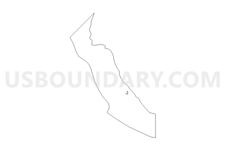
Outline

Summary
| Unique Area Identifier | 690021 |
| Name | Water: Rosario Strait |
| County | Whatcom County |
| State | Washington |
| Area (square miles) | 14.09 |
| Land Area (square miles) | 0.00 |
| Water Area (square miles) | 14.09 |
| % of Land Area | 0.00 |
| % of Water Area | 100.00 |
| Latitude of the Internal Point | 48.67957900 |
| Longtitude of the Internal Point | -122.68815780 |
Maps

Graphs
Select a template below for downloading or customizing gragh for Water: Rosario Strait, Whatcom County, Washington


Neighbors
Neighoring Voting District (by Name) Neighboring Voting District on the Map
- Voting District 122, Whatcom County, WA
- Guemes Voting District, Skagit County, WA
- Orcas 4 Voting District, San Juan County, WA
- Water: Bellingham Bay Leg 42, Whatcom County, WA
- Water: Strait of Georgia, Whatcom County, WA
Top 10 Neighboring County Subdivision (by Population) Neighboring County Subdivision on the Map
- Anacortes CCD, Skagit County, WA (20,332)
- Orcas CCD, San Juan County, WA (5,354)
- Lummi Island CCD, Whatcom County, WA (964)
Top 10 Neighboring Unified School District (by Population) Neighboring Unified School District on the Map
- Ferndale School District, WA (30,392)
- Anacortes School District, WA (20,332)
- Orcas Island School District, WA (5,387)
Top 10 Neighboring State Legislative District Lower Chamber (by Population) Neighboring State Legislative District Lower Chamber on the Map
Top 10 Neighboring State Legislative District Upper Chamber (by Population) Neighboring State Legislative District Upper Chamber on the Map
Top 10 Neighboring 111th Congressional District (by Population) Neighboring 111th Congressional District on the Map
Top 10 Neighboring Census Tract (by Population) Neighboring Census Tract on the Map
- Census Tract 109, Whatcom County, WA (964)
- Census Tract 9901, San Juan County, WA (0)
- Census Tract 9901, Skagit County, WA (0)